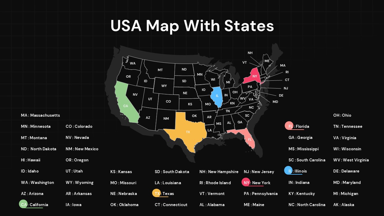
Black usa-map-with-states-powerpoint-

This template is part of a deck featuring multiple slides. To check out all slides.

See All
USA map slide with all states outlined and labeled, selected states highlighted in different colors on a clean grid background.

Product Description

USA States Labeled Map Presentation Template

This USA map with states overview slide is designed to help presenters clearly visualize and communicate geographic information across the United States. Featuring a clean outline of all 50 states with clearly marked borders and postal abbreviations, this USA map with states layout makes regional data easy to understand at a glance. Selected states are highlighted in contrasting colors, allowing you to emphasize key locations, focus regions, or comparative insights without overwhelming the audience. The neutral background grid and balanced spacing ensure the map remains the central focus while preserving a professional, presentation-ready look.

Built for flexibility, this USA map with states slide supports a wide range of business, educational, and analytical use cases. You can recolor individual states, add labels or callouts, and overlay icons or data points to reflect sales territories, market penetration, operational coverage, or demographic trends. The vector-based design ensures sharp rendering at any size and seamless editing in both PowerPoint and Google Slides, eliminating formatting issues during collaboration or sharing.

Whether you are presenting to executives, students, or stakeholders, this map simplifies complex geographic discussions and improves audience engagement. By combining clarity, customization, and visual consistency, the slide enables you to transform raw location data into a compelling visual narrative suitable for reports, dashboards, and strategic presentations.

Features of this template

• Fully editable USA map with all states clearly outlined and labeled.
• Individual state coloring to highlight regions, focus areas, or comparisons.
• Clean, grid-based background that enhances readability without distraction.
• Vector shapes optimized for PowerPoint and Google Slides compatibility.

Why use this template

• Communicate geographic data clearly and professionally in one slide.
• Save time creating custom maps from scratch.
• Improve audience understanding of regional insights and coverage.
• Reuse across reports, presentations, and strategic decks with easy updates.

Who is it for

Business analysts, consultants, educators, sales managers, marketers, and researchers who need to present U.S. geographic data clearly. Ideal for regional performance reviews, market analysis, territory planning, academic lessons, and executive summaries.

Login to download this file

What do you think about this template? Give a rating