


Map of Northeastern US for PowerPoint & Google Slides


Northeastern United States Regional Map Presentation Template
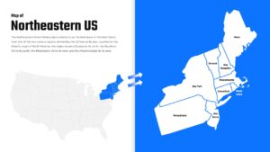
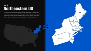
This Map of Northeastern US Template for PowerPoint & Google Slides provides a professional split-screen layout featuring detailed geographic visualization of the Northeast region. The design utilizes a clean blue and white color scheme with bright blue accents, combining comprehensive state-by-state mapping with organized text sections. Each slide displays clear state boundaries, readable labels for all northeastern states, and includes both overview and detailed regional perspectives for comprehensive geographic representation.
This Map of Northeastern US Template for PowerPoint & Google Slides is ideal for educators conducting geography lessons, business professionals analyzing regional markets, government officials presenting demographic data, and researchers studying northeastern territories. The template supports educational presentations, corporate regional analysis, marketing strategies targeting northeastern markets, economic reports, demographic studies, and any presentation requiring clear geographic reference to Maine, Vermont, New Hampshire, Massachusetts, Rhode Island, Connecticut, New York, Pennsylvania, and New Jersey.
The template offers complete customization options allowing users to modify colors, text content, and geographic details to match specific presentation needs. Users can easily update state information, adjust color schemes, and incorporate additional data points. This flexibility ensures presentations remain professional while delivering targeted geographic insights that enhance audience understanding and engagement.
Features of this Map of Northeastern US template
• Professional split-screen layout with text and map sections
• Clean blue and white color scheme with high contrast design
• Detailed state boundaries and labels for all northeastern states
• Dual perspective view with overview and detailed regional mapping
• Consistent design elements across multiple slide variations
Why use this Map of Northeastern US template
• Enhances geographic presentations with professional visual appeal
• Saves time with pre-designed layout and accurate state mapping
• Supports various presentation needs from education to business analysis
• Provides clear regional focus for targeted audience engagement
Who is it for
This template is perfect for geography teachers, business analysts, marketing professionals, government officials, researchers, corporate presenters, educational institutions, regional planners, demographic specialists, and anyone requiring professional northeastern US geographic visualization for presentations, reports, or educational materials.
Login to download this file


