


West Africa Political Map Overview Template for PowerPoint & Google Slides


West Africa Countries Labeled Map Presentation Template
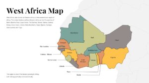
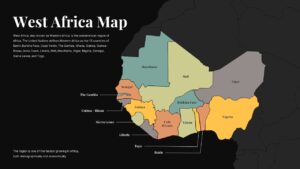
This West Africa political map slide is designed to present a clear, labeled overview of the West African region with a clean and professional visual structure. The template highlights individual countries using distinct color blocks, making it easy to differentiate national boundaries while maintaining a cohesive geographic layout. Country names are placed directly within each area, supported by subtle leader lines for smaller nations along the coast, ensuring readability without visual clutter. The neutral background keeps the focus on the map, while the balanced typography adds an academic and authoritative tone suitable for formal presentations.
Optimized for PowerPoint and Google Slides, this West Africa political map supports effortless customization for educational, governmental, or business use. You can adjust colors, add data overlays, or annotate specific countries to support regional analysis, economic discussions, or geopolitical briefings. The scalable vector layout ensures sharp visuals on large screens, printed materials, or shared digital files. Whether used as a standalone slide or as part of a larger deck, this map provides a reliable foundation for explaining regional structure and country-level context.
As a versatile geographic asset, this West Africa political map is ideal for explaining demographic trends, regional growth, trade corridors, or development initiatives. Its straightforward design helps audiences quickly understand spatial relationships across the region while supporting deeper insights through added labels, icons, or callouts tailored to your message.
Features of this West Africa political map template
• Clearly labeled West African countries with distinct color segmentation.
• Clean political map layout with readable typography and balanced spacing.
• Editable vector shapes compatible with PowerPoint and Google Slides.
• Neutral background optimized for annotations, highlights, and overlays.
Why use this template
• Simplifies regional explanations with an easy-to-read geographic structure.
• Enhances clarity in educational, analytical, and strategic presentations.
• Saves design time with a ready-to-use, professionally styled map slide.
• Adapts seamlessly to reports, lectures, and executive briefings.
Who is it for
Educators, students, researchers, policy analysts, consultants, and business professionals presenting regional insights, geographic context, or country-level analysis related to West Africa.
Login to download this file


